Fil:PIA21182 - Bardsey Island, Wales.jpg

Beskrivelse
| Beskrivelse |
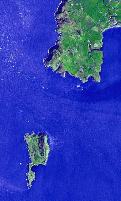
English: Lying 3 km off the Llyn peninsula of Wales, the Bardsey Island is known as the Island of 20,000 saints. While today's permanent population numbers only four, the island was once an important religious site, with a 6th century monastery. It is the legendary burial site of King Arthur. Another legend holds that anyone who died on the island would not go to hell. The image was acquired April 4, 2006, covers an area of 6 by 10 km, and is located at 52.7 degrees north, 4.8 degrees west.
With its 14 spectral bands from the visible to the thermal infrared wavelength region and its high spatial resolution of 15 to 90 meters (about 50 to 300 feet), ASTER images Earth to map and monitor the changing surface of our planet. ASTER is one of five Earth-observing instruments launched Dec. 18, 1999, on Terra. The instrument was built by Japan's Ministry of Economy, Trade and Industry. A joint U.S./Japan science team is responsible for validation and calibration of the instrument and data products. The broad spectral coverage and high spectral resolution of ASTER provides scientists in numerous disciplines with critical information for surface mapping and monitoring of dynamic conditions and temporal change. Example applications are: monitoring glacial advances and retreats; monitoring potentially active volcanoes; identifying crop stress; determining cloud morphology and physical properties; wetlands evaluation; thermal pollution monitoring; coral reef degradation; surface temperature mapping of soils and geology; and measuring surface heat balance. The U.S. science team is located at NASA's Jet Propulsion Laboratory, Pasadena, Calif. The Terra mission is part of NASA's Science Mission Directorate, Washington, D.C. More information about ASTER is available at http://asterweb.jpl.nasa.gov/. |
| Dato | 4 April 2006 (published 1 December 2016) |
| Kilde | Catalog page · Full-res (JPEG · TIFF) |
| Opphavsperson | NASA/METI/AIST/Japan Space Systems, and U.S./Japan ASTER Science Team |
| Posisjon på Mars | Dette og andre bilder på denne posisjonen på: Google Maps |
|---|
This image or video was catalogued by Jet Propulsion Laboratory of the United States National Aeronautics and Space Administration (NASA) under Photo ID: PIA21182. This tag does not indicate the copyright status of the attached work. A normal copyright tag is still required. See Commons:Licensing. Other languages:
|
| This media is a product of the Terra mission Credit and attribution belongs to the mission team, if not already specified in the "author" row |
Lisensiering
| This file is in the public domain in the United States because it was solely created by NASA. NASA copyright policy states that "NASA material is not protected by copyright unless noted". (See Template:PD-USGov, NASA copyright policy page or JPL Image Use Policy.) | ||
 |
Warnings:
|
Filhistorikk
Klikk på et tidspunkt for å vise filen slik den var på det tidspunktet.
| Dato/klokkeslett | Miniatyrbilde | Dimensjoner | Bruker | Kommentar | |
|---|---|---|---|---|---|
| nåværende | 25. feb. 2017 kl. 14:30 | | 395 × 655 (54 KB) | wikimediacommons>PhilipTerryGraham | User created page with UploadWizard |
Filbruk
Den følgende siden bruker denne filen: