Fil:JordanRiver en.svg

Opprinnelig fil (SVG-fil, standardstørrelse 1 016 × 1 285 piksler, filstørrelse: 809 KB)
Beskrivelse
| Beskrivelse |
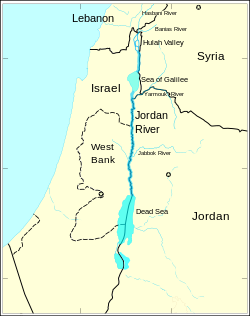
English: The Jordan River. Modified from http://www.un.org/Depts/Cartographic/map/profile/israel.pdf
Cross-checked with other maps, especially in the area of the Hula swamp and the tributaries: |
| Dato | |
| Kilde | http://www.un.org/Depts/Cartographic/map/profile/israel.pdf |
| Opphavsperson | Eget verk |
| Andre versjoner |
|


![[1]](http://www.ce.utexas.edu/prof/mckinney/ce397/Topics/Jordan/jordanb.jpg)
![[2]](http://www.idrc.ca/IMAGES/books/907/ch8img3.gif)
![[4]](http://www.think-israel.org/mar05pix/tributaries.gif)
![[6]](http://www.asharqalarabi.org.uk/images1/Image.gif)
Lisensiering
| This image is a map derived from a United Nations map.
Unless stated otherwise, UN maps are to be considered in the public domain. This applies worldwide. UN maps are, in principle, open source material and you can use them in your work or for making your own map. UN requests however that you delete the UN name, logo and reference number upon any modification to the map. Content of your map will be your responsibility. You can state in your publication, if you wish, something like: based on UN map … (map name, map number, revision number and date). See: Geospatial Information Section. And: Geospatial, location data for a better world. |
 |
Filhistorikk
Klikk på et tidspunkt for å vise filen slik den var på det tidspunktet.
| Dato/klokkeslett | Miniatyrbilde | Dimensjoner | Bruker | Kommentar | |
|---|---|---|---|---|---|
| nåværende | 25. mai 2023 kl. 10:48 | | 1 016 × 1 285 (809 KB) | wikimediacommons>Illchy | File uploaded using svgtranslate tool (https://svgtranslate.toolforge.org/). Added translation for id. |
Filbruk
De følgende 2 sidene bruker denne filen: